Pipeline Markers
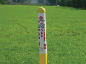 The location of Gulfstream’s underground pipelines is identified by aboveground yellow markers containing the company’s emergency contact information. Markers are present whenever a pipeline crosses under roads, railroads or waterways. While pipeline markers indicate the presence of a pipeline, the absence of a pipeline marker is no assurance that a pipeline is not present, especially in metropolitan and agricultural areas. Also, it is important to note that the presence of markers does not necessarily represent the exact location of the pipeline within the easement.
Easements
Gulfstream’s transmission pipelines normally follow well-defined easements, many times sharing the same corridor with other utility lines (power lines, communications, fiber op tic cables, etc). The width of these easements varies depending on the number of pipelines and terrain. Easements give pipeline operators like Gulfstream the right to construct, operate and maintain the pipeline. Aboveground structures, trees and other deep-rooted shrubs are not permitted within the pipeline easement.
National Pipeline Mapping System
The National Pipeline Mapping System (NPMS) is an online mapping system created to educate the public about pipelines in their community. Enter your ZIP code and NPMS provides a list of pipelines, their location, general commodities transported and operator contact information. NPMS can be accessed on the Internet at www.npms.phmsa.dot.gov.